

Are you looking for professional drone services in Bristol, CT?
Overlook Drone Solutions provides professional drone inspections, aerial photography, and construction videography throughout Bristol, Connecticut. Our FAA-certified pilots deliver high-resolution imagery, 3D mapping, and cinematic video that help contractors, property managers, and marketing teams make confident decisions from above.
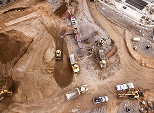
Drone Inspection Services in Bristol, CT
We specialize in detailed, safe, and efficient drone inspections for construction sites, roofs, façades, and infrastructure projects.
Our advanced drones capture accurate data and high-definition visuals—reducing field time and keeping your team out of hazardous areas.
Inspection Capabilities:
-
Site grading and drainage documentation
-
Utility, bridge, and tower inspections
-
Thermal and visual inspections for hard-to-reach areas
Each inspection includes geo-referenced imagery, annotated visuals, and deliverables customized for engineers, developers, and insurers.
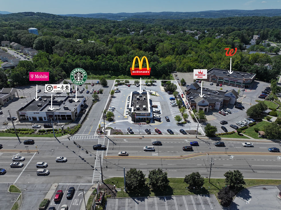
Aerial Photography & Videography in Bristol
Whether you’re promoting a new commercial development, documenting construction milestones, or showcasing your property portfolio, our cinematic aerial media gives your project a professional edge.
Deliverables include:
-
4K aerial videos and photography
-
Marketing videos for contractors and real estate
-
Drone footage editing with logo and text overlays
-
Ground + aerial combined shoots
We tailor every shoot for your vision—perfect for local developers, marketing agencies, and small businesses in Bristol.

Construction Drone Mapping & Progress Documentation
Stay on top of project timelines with accurate aerial mapping and 3D modeling.
We create orthomosaic maps, volume calculations, and digital surface models to support site planning, compliance, and stakeholder updates.
Applications:
-
Construction progress tracking
-
Cut/fill analysis
-
As-built verification
-
Site safety documentation
-
Aerial surveying for pre-construction planning
All data is captured using FAA-compliant flight plans and delivered in accessible formats such as JPEG, TIFF, PDF reports, or web-based viewers.


Aerial and Ground Photography
We provide professional ground and aerial photography and videography that capture properties, projects, and events from every angle, delivering high-quality visuals for marketing, construction, and real estate needs.
Aerial Video
We create cinematic aerial videos that showcase properties, landscapes, and projects with stunning perspectives only possible from above.
Annotated Photo and Video
We deliver annotated photos and videos that combine high-resolution visuals with clear labels, callouts, and measurements to communicate information with precision and impact.
Why Choose Overlook Drone Solutions?
-
Local Experience — we serve Stamford, Greenwich, Norwalk, Darien, Westport, and all of Fairfield County
-
Licensed & Insured — FAA Part 107 certified drone pilots
-
Professional Quality — ultra-high-resolution photos, stabilized video, and precise mapping
-
Flexible Deliverables — JPEG, TIFF, MP4, orthomosaics, 360° virtual tours, and annotated video
FAQs: Bristol Drone Services
1. What types of drone inspections do you offer in Bristol, CT?
We provide a full range of visual and thermal drone inspections for construction, roofing, façades, utilities, and property documentation. Each inspection includes high-resolution photos, videos, and optional orthomosaic maps for precise analysis and reporting.
2. Are your drone pilots certified and insured?
Yes. All Overlook Drone Solutions pilots are FAA Part 107 certified and fully insured for both commercial and municipal operations across Connecticut. We follow all local and federal UAS flight regulations to ensure safe, compliant missions.
3. Can you fly drones in downtown Bristol or near Lake Compounce?
Yes—most areas of Bristol are unrestricted for drone operations, though certain sites near airports or public facilities may require airspace authorization. We handle all necessary flight planning, airspace checks, and approvals before each project.
4. What is included in your construction drone mapping services?
Our construction drone mapping includes aerial data capture, orthomosaic maps, 3D models, and volumetric measurements. Deliverables are provided in JPEG, TIFF, PDF, or web-viewable formats for easy integration into your planning or reporting workflows.
5. How long does it take to receive photos and videos after a flight?
Most projects are delivered within 2–3 business days, depending on complexity and editing requirements. For large construction progress mapping projects, we can provide same-day previews and full deliverables within a week.
6. Do you provide both ground and aerial footage?
Absolutely. We often combine ground-level video and drone footage to create dynamic marketing visuals for contractors, developers, and local businesses. Our editing team can merge both perspectives into a cinematic, branded final video.
7. How do I request a quote for a Bristol project?
You can contact Overlook Drone Solutions directly through our online form or by phone. Provide your project location, type of service (inspection, photography, or mapping), and desired timeline. We’ll respond with a custom quote and flight plan within 24 hours.
8. What areas around Bristol do you serve?
We provide drone services throughout Bristol, Plainville, Southington, New Britain, Farmington, and the greater Hartford County region. Our team can mobilize quickly for both one-time shoots and ongoing construction monitoring.
9. Can you assist with permits or restricted airspace authorization?
Yes. Our team regularly works with FAA LAANC authorizations and local municipalities to ensure full compliance for each flight. You don’t need to handle any of the permitting—we take care of all documentation and airspace coordination.
10. What industries benefit most from your drone services?
Our Bristol-area clients include construction firms, real estate developers, roofers, solar installers, insurance adjusters, and marketing agencies. Whether you need visual inspections, marketing videos, or 3D site mapping, we tailor every flight to your project goals.
Book a Free Consultation
We’ll help you map out the best approach — no pressure, no commitment.
Additional Areas We Serve
We cover commercial properties throughout the Hudson Valley, including:
-
Dutchess County – Beacon, Wappingers Falls, Fishkill, East Fishkill, Hyde Park, Rhinebeck, Red Hook, Millbrook
-
Ulster County – Kingston, New Paltz, Saugerties, Woodstock, Ellenville, Hurley, Marbletown, Rosendale
-
Orange County – Newburgh, Middletown, Goshen, Warwick, Monroe, Cornwall, Montgomery
-
Putnam County – Carmel, Brewster, Cold Spring, Patterson, Kent
-
Westchester County – White Plains, Yonkers, New Rochelle, Mount Vernon, Peekskill, Rye, Port Chester, Ossining, Tarrytown
Albany Capital Region
Serving commercial and municipal properties throughout the Capital Region, including:
-
Albany, Troy, Schenectady, Saratoga Springs, Clifton Park, Colonie, Rensselaer
Catskills
Serving resort towns, villages, and rural communities, including:
-
Woodstock, Hunter, Tannersville, Windham, Phoenicia, Margaretville, Roxbury, Andes, Delhi, Liberty, Livingston Manor, Roscoe
We cover commercial properties throughout the five boroughs:
-
Brooklyn
-
Queens
-
The Bronx
-
Staten Island
New Jersey
Full coverage across North and Central New Jersey, including:
-
Newark, Jersey City, Hoboken, Paterson, Clifton, Elizabeth, Morristown, Hackensack, Paramus, Edison, New Brunswick, Princeton
Connecticut
We serve major cities and surrounding areas across Connecticut, including:
-
Hartford, Bridgeport, New Haven, Norwalk, Danbury, Waterbury, Greenwich
Pennsylvania
Commercial aerial and ground services in Eastern PA, including:
-
Philadelphia, Allentown, Bethlehem, Easton, Reading, Scranton, Wilkes-Barre, Stroudsburg, Pocono region