
Reliable Solutions,
Start to Finish

Fast Delivery

Dedicated to Safety

Licensed Drone Pilots


Save Time and Reduce Costs with Drone Construction Monitoring
Streamlined Construction Workflow with Aerial Intelligence
Avoid delays by tracking progress and resource use in real time.
Keep everyone aligned by delivering clear, visual updates to stakeholders.
OUR CONSTRUCTION DRONE OFFERINGS

Progress Monitoring

Photogrammetry

Photo and Video

360-degree Tours
Aerial Construction Marketing Photography & Video
Professional Drone Photography & Video for Construction, Commercial Real Estate, and Businesses Across the Tri-State Area
Capture Milestones. Monthly Photo & Video
Capture your construction project from start to finish with scheduled drone photography and video at every critical milestone. Select the visit frequency that fits your workflow, and add advanced tools like 3D mapping, high-resolution orthomosaics, and timelapse coverage for detailed site monitoring and progress tracking.
Orthomosaic Mapping for Accurate Site Documentation
Orthomosaics are high-resolution, geo-referenced aerial maps that give contractors and developers an accurate top-down view of their construction site. They offer centimeter-level accuracy for tracking progress, verifying work, measuring stockpiles, and creating reliable documentation.
Captured weekly, monthly, or quarterly, orthomosaics provide a clear visual record from groundbreaking to completion, improving communication, reducing rework, and supporting inspections and compliance.
We provide construction drone mapping, orthomosaic surveys, and progress monitoring across New York, the Hudson Valley, Albany, and NYC with professional, accurate results.

2025 Site Gallery – Aerial Progress Documentation
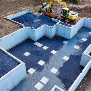
Saved flight plans let us capture the same angles every time, ensuring perfectly aligned images for side-by-side comparisons, progress tracking, and reporting.

360° Panoramic Views – Step Inside Your Site Remotely
360° panoramic images provide an immersive, true-to-life view of your construction site—click below to explore!
FAA Certified & Fully Insured
The Flight Plan
01
02
03
01
Schedule a Free Consultation
Fly the Mission
Fast Turnaround, Guaranteed
We’ll review your needs, answer any questions you have, and provide a customized quote for your project.
Your drone flight will be handled by experienced pilots, with deliverables delivered promptly.
Get high-quality drone deliverables in just days—not weeks—so your project stays on schedule.
Book a Free Drone Consultation
We’ll help you map out the best approach — no pressure, no commitment.
Areas We Serve
Construction Drone Services
Aerial Photography & Videography
Hudson Valley, NY – Construction Drone Services
We provide full construction drone services in the Hudson Valley, delivering aerial photography, video, mapping, and progress monitoring for contractors and developers. Our service area includes:
-
Dutchess County – Poughkeepsie, Beacon, Wappingers Falls, Fishkill, East Fishkill, Hyde Park, Rhinebeck, Red Hook, Millbrook
-
Ulster County – Kingston, New Paltz, Saugerties, Woodstock, Ellenville, Hurley, Marbletown, Rosendale
-
Orange County – Newburgh, Middletown, Goshen, Warwick, Monroe, Cornwall, Montgomery
-
Putnam County – Carmel, Brewster, Cold Spring, Patterson, Kent
-
Westchester County – White Plains, Yonkers, New Rochelle, Mount Vernon, Peekskill, Rye, Port Chester, Ossining, Tarrytown
Albany & Capital Region – Drone Services for Construction Projects
Our Albany area construction drone services support contractors, developers, and municipalities across the Capital Region. From progress monitoring to aerial mapping and marketing visuals, we cover:
-
Albany County – Albany, Colonie, Guilderland, Bethlehem, Cohoes, Watervliet
-
Rensselaer County – Troy, Rensselaer, East Greenbush, North Greenbush, Hoosick Falls
-
Schenectady County – Schenectady, Niskayuna, Scotia, Glenville
-
Saratoga County – Saratoga Springs, Clifton Park, Halfmoon, Ballston Spa, Wilton, Malta
Catskills, New York – Aerial Drone Solutions for Construction
From mountain resorts to rural towns, our Catskills construction drone services help builders and developers document progress, manage budgets, and market properties. We serve: Woodstock, Hunter, Tannersville, Windham, Phoenicia, Margaretville, Roxbury, Andes, Delhi, Liberty, Livingston Manor, and Roscoe.
New York City – Construction Drone Inspections & Marketing
We offer aerial construction photography, videography, and inspection services across all five NYC boroughs:
New Jersey – Drone Services for Construction Sites
Our New Jersey construction drone services cover North and Central NJ, supporting contractors with site inspections, progress documentation, and marketing visuals. Service areas include Newark, Jersey City, Hoboken, Paterson, Clifton, Elizabeth, Morristown, Hackensack, Paramus, Edison, New Brunswick, and Princeton.
Pennsylvania – Construction Drone Services in Eastern PA
We work with contractors and developers across Eastern Pennsylvania to deliver high-resolution drone mapping and aerial photo/video documentation. Coverage includes Philadelphia, Allentown, Bethlehem, Easton, Reading, Scranton, Wilkes-Barre, Stroudsburg, and the Pocono region.
Connecticut – Drone Construction Mapping & Monitoring
We support construction projects in Connecticut with aerial photography, videography, orthomosaic mapping, and 3D site modeling. Areas served include:
-
Litchfield County – New Milford, Litchfield, Sharon, Canaan, Kent, Cornwall, Washington Depot, Roxbury, Barkhamsted, Riverton, Pleasant Valley
-
Fairfield County – Danbury, Greenwich, Stamford, Norwalk, Ridgefield, New Canaan, Wilton, Bethel
-
Windham County – Woodstock, Thompson, Putnam, Eastford, Killingly, Pomfret, Brooklyn
-
Hartford County – Hartford, Simsbury, Farmington, Avon, Bloomfield, Bristol, Newington, Manchester, West Hartford
-
New Haven County – Waterbury, New Haven, Cheshire, Meriden, Naugatuck, Wallingford, Hamden


